Revitalising urban drainage channels: Designing a sustainable city that lives in harmony with water
Hong Kong is a highly developed and densely populated city. It has a population of approximately 7.5 million living on a total land area of 1,100 km². The majority of the population is distributed in a crowded urban area that contributes approximately 30% of Hong Kong’s total land area.
In the 1950s, several open drainage channels – commonly referred to as “nullahs” – were constructed in concrete and in the Kowloon peninsula, the most densely populated urban area of Hong Kong. Nullahs were mainly designed for flood protection, relieving the surface runoff from the hinterland and the urban area of Kowloon. Most of them were converted from natural streams when the city was developed.
Initially, due to the lack of a well-established sewerage network, foul water was discharged into these nullahs, causing serious hygiene issues. The nullahs also emitted foul odours to the surrounding neighbourhood. To address the odour issue and to cater for urban development, many of them have been decked over to become drainage box culverts beneath roads and other infrastructure over the intervening decades. At the same time, both the sewerage and drainage systems have been well and widely established in the city, resolving the odour problem.
Recently, conservation and the environment have become a much-discussed topic. Understanding these are the vital elements to build a sustainable city, people are now far more willing to preserve infrastructure and buildings that have historic and ecological values. Hong Kong was historically reliant on water for its agricultural trade between the 1950s and 1970s, and the community in Hong Kong is keen to preserve this heritage through welcoming more water-friendly facilities in the city.
Protection of neighbourhoods against floods is also no longer the sole function of the nullah – people would prefer to see green river channels with water features, landscaping, ecological and environmental enhancement – and a space that allows the community and nature to co-exist harmoniously. This is particularly true when the Hong Kong Government undertook the Revitalisation of Kai Tak Nullah project.
Hong Kong’s first urban green river channel: Kai Tak Nullah
During the initial stages of the project, the drainage nullah was planned to be decked over to create an open space for the public. This was not well received by the general public and the community advocated that it should be preserved. The nullah has an historical significance. The drainage channel can be traced back to the natural stream well days before the modern city was formed. It supplied water to several villages in historical Hong Kong, one of which was the walled village of Nga Tsin Wai Tsuen – the last remaining walled village in Kowloon, spanning over 600 years and partly remaining to this day.
The public feelings prompted the Government to reshape its plans. In 2009, the government kickstarted a project to reconstruct and revitalise Kai Tak Nullah with landscape and ecological measures, backed by engineering support to strengthen the aged nullah structure.
Improving existing nullahs in urban areas is challenging and requires many considerations
In 2018, the Kai Tak Nullah (now renamed as Kai Tak River) revitalisation project was successfully completed. The process of revitalising the Kai Tak Nullah revealed the challenges that are likely to be faced by other similar projects:
- Due to urban developments and extreme weather conditions in recent years, the nearby residents experienced flooding during monsoon seasons. It proved that the nullah was no longer able to meet the current flood prevention standards. It was vital to resolve the drainage bottlenecks in the nullah, such as utility crossings and narrow channel widths.
- The nullah was surrounded with roads and developments. Spatial constraints imposed difficulties in widening the nullah as well as providing adequate site space for construction.
- There was a dry weather flow from the upstream catchments to the nullah. The dry weather flow contained undesirable discharges from wet markets, garages and restaurants. This caused water pollution and an odour problem.
- To resolve the odour problem during periods of dry weather, the nullah started receiving treated effluent discharged from the Tai Po and Shatin Sewage Treatment Works in the 1990s. Although it provided continuous flushing along the nullah, it had created a strong flow and made the nullah a harsh habitat for small fish.
Welcoming the future with an integrated engineering design solution
Taking the landscape, ecology and environment into consideration when providing engineering design solutions in revitalisation projects has become essential. At Aurecon, we believe that engineers should be delivering solutions in an holistic way to find the right balance of environmental and human activity.
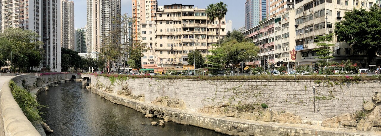
For example, with the Kai Tak River, to strengthen the wall stability of the ageing nullah structure, piling was introduced. The nullah was widened in some sections, allowing for additional box culvert installation in parallel with the nullah under the adjacent road to increase its sectional capacity. Public utilities located in the nullah were also diverted or removed to improve the flow and capacity, as well as to avoid flooding.
To restore the natural habitat, fish shelters and wetland plantations were implemented along the nullah. A two-year planting trial was carried out in the design stage to identify suitable species tolerant to the high salinity content of the nullah flow. It was followed by a full-scale implementation during the construction process. Artificial rocks were used to create natural boulders on the nullah bed and around the wetland species. These helped slow the flow and create a fertile habitat for small fish.
Polluted dry weather flow was intercepted with an upgraded dry weather interceptor channel along the side of the nullah, which was covered with hard landscape. The intercepted dry weather flow was then conveyed to the downstream system. This improved the overall water quality and appearance of the nullah flow.
A facelift was given to the walls and edges of the nullah, introducing granite facing and edge planters. Footbridges crossing the nullah were reconstructed or refurbished to align with the new look. Post construction ecological monitoring was also carried out and the results indicated an increase of avian and fish species in the area. Now, Kai Tak River is a local attraction and an ideal place for the community to enjoy leisure and public activities.


Another similar project in the urban area, the revitalisation of Tsui Ping River (previously named as King Yip Street nullah), is currently underway. The 1km-long existing nullah will be transformed into a unique river through extensive environmental, ecological and landscaping improvement works. The river will also enhance pedestrian connectivity through improvement works to the local pedestrian network. This project is scheduled for completion by 2023.

Looking ahead: Expanding river channel revitalisation to rural areas to facilitate sustainable city development
The success of the Kai Tak River project has not only created a positive impact on the community, but also encouraged the authorities to take a further step forward and explore opportunities to integrate public open spaces with rivers or drainage channels in the rural area. This helps Hong Kong in its pursuit of being a water-friendly city.
In recent years, the Drainage Services Department has also conducted a study on floodable open space in the New Territories (rural area). This concept was not considered viable in the past because it was dangerous to let the public enter the drainage and river channels as flash floods can occur during excessive rainfall. With advanced weather forecast technology and sophisticated flood warning systems in place, the Government can now develop extensive river networks with the integration of floodable open spaces in rural areas. This allows people to make use of the drainage space for different recreational and leisure activities.

In addition, landscape treatment with ecological restoration and enhancement measures can be implemented to convert the engineered river channels into a more naturalistic environment for the habitat of birds and fish. All these environmental, landscape and ecological protection efforts can provide a strong infrastructure foundation for different new town development projects in the North East and North West of the New Territories in the next few decades. As the Government aims to promote work-life balance as well as foster nature-living and community-living in the new towns, these initiatives can help Hong Kong realise its long-term, sustainable development plans.
Contracts Manager at Build King Holdings Limited
2yA good article to review the history and development of flood prevention and sewerage strategy in Hong Kong.
Senior Project Advisor at Halton Region
2yLooks good! Better than the renderings during design.